4. Among Romans, Avars and Bavarians
Pax Romana
The militarily organized administration of the Romans brought almost 160 years of peace to the Ufernoricum (waterside Noricum as far as to the Danube). The population of Noricum quickly adopted the Roman way of life and culture, especially in the cities. After Juvavum (Salzburg), Ovilava (Wels) was the seat of the proconsul with his official apparatus. Certainly also important for Traunkirchen and the surrounding country estates of disused legionnaires. New cities were founded, villages and farmsteads were opened up by roads and tracks. The ancient trade with Italy, the south and with the peoples in the north could proceed peacefully at this time.
Important Roman trade links
Under Emperor Caracalla (211 - 217 AD) the Juvavum route, which was also important for Traunkirchen, expanded via Tergolape (Schwanenstadt) to Ovilava and from there to Celium (St. Pölten). A trade connection from Wels via Aurachkirchen to the upper Salzkammergut can be assumed with certainty, although not shown.
With Bavarians against Avars
The armed conflicts in the "Migration Period" (3rd century to the 6th century) led to the withdrawal of the Romans. Since the 6th century Avars, which were only conquered by Charlemagne, devastated the country. The Slavs were in the south. In the 7th and 8th century the population shrank, so that the foothills of the Alps and the Eastern Alps, including the Traunsee area, were fairly sparsely populated. In two centuries, the Bavarian dukes of the Agilolfinger dynasty, commissioned by the Franconian king, rebuilt this post-Roman area with freemen who were subject to military and tribute duties. They uprooted and missionized, even for a long time still pagans, the partly again or still pagan population. Free people were often no longer able to pay their tribute due to the many war campaigns, placed themselves under the protection of a more powerful person and thereby lost their property. Thus the land ownership of the duke and the noble families increased, and with it their power in the country.
Image information
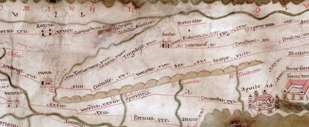
Tabula Peutingeriana
The Tabula Peutingeriana is a 12 piece map of the Roman roads of the entire Roman Empire from the 4th century (c. 375 AD). It was made in parchment in the 12th century created as a copy of the original map. The province of Noricum is only shown in a rudimentary form. The Salzkammergut is not included on the map, only section Ovilava - Juvavum can be seen in this section 4. Prince Eugene acquired it from an Augsburg native, Mr. Peutinger, in 1715. The original is in the Austrian National Library in Vienna.
© E. Rumpf, R. Hofbauer; Translation: XiBIT Infoguide GmbH